Thank God for high pressure systems! With the weather forecast clear and warm over the Canadian Rockies, Mike and I spent much of our work weeks plotting a scramble! We eventually settled on Mount Whymper because, despite Kane’s underwhelming description in the guide, any trip reports that we could find suggested that this objective would present a delightful hands-on scramble with exceptional views. Our (permanent) resident French girl Aurore asked if she could join and we agreed since we tend to behave better in the presence of a lady. We were also intrigued by the fact that none who published their trip reports felt that they were on Kane’s route. Ultimately, I suspect that we didn’t manage to stay on Kane’s route either since the terrain higher up became more difficult than moderate (but more on that later).
.jpg)
The highway-side view of Mount Whymper from the Stanley Glacier parking lot. Kane’s route ascends the large avalanche chute on the far right where very little deadfall remains and bushwhacking is more or less non-existent. From there, the route ascends rock steps in a gully before crossing left to the skyline ridge at an ambiguous point. Most people seem to feel that they’ve gone off-route by traversing left too early or too late. There is, apparently, one spot somewhere in between where the whole way is moderate and no steeper than the first rock band. Suffice to say we didn’t find that spot.
.jpg)
Just what we need to make this scramble more interesting: hidden explosives!
.jpg)
Fall colours in full swing looking south down Highway 93 towards Radium. Vermillion Peak beyond the recovering forest.
.jpg)
Aurore provided our amusement for the morning. Here she chases her helmet back down a steep slope after non-chalantly placing it round-side down on a hill. Better still, when it finally stopped rolling and she was able to catch up to it, she accidentally kicked it, sending it tumbling a further 50 – 100 feet downslope. Mike and I being the gentlemen that we are, laughed on from our comfortable perches above.
.jpg)
Mike getting into the fun stuff!
.jpg)
The first and, supposedly, steepest rock band (if you stay on route).
.jpg)
Aurore and I enjoy a steep diversion on the way up. A backlit Mount Stanley provided a visual highlight while we ascended.
.jpg)
Stairway to heaven! Lots of great hands-on scrambling on this mountain. Once we got above the grassy slopes of the avalanche chute, we ascended the gully on the right (which appeared to be a little less steep) before traversing slightly left and going straight up the staircase pictured here.
.jpg)
This is where our route-finding senses started to tell us to traverse climber’s left to the skyline ridge as Kane suggests. We had, however, read one trip report which warned against traversing too early due to difficult terrain on the ridge. As a result, we continued upwards where we could see the terrain steepening (devil you know). If I go back to this peak, I will most certainly investigate the leftward traverse across this slope.
.jpg)
By not traversing we ended up on this terrain which became progressively looser and steeper as we ascended. Above Mike and Aurore, there are three gullies which break the rock band. The gully on the left is clearly technical while the one in the center and the one on the right appear to be possibilities. Ultimately, we ascended the gully in the center. A word of caution: while the gully on the right appears to be scramble-able, it does not connect with the central gully above the rock band. Ultimately, I believe that taking the gully on the right would make your eventual left-ward traverse to gain the summit ridge more challenging than it need be.
.jpg)
Improving views of Mount Ball and Stanley Peak from high up the ever-steepening gully.
.jpg)
Mike and Aurore ascend the center gully, distinguished from others by a car-sized cubic boulder in the bottom right of this photo. The climb up this gully was…stimulating. For the most part, the ledges are good, however, there is a right-ward traverse across one 2 inch-wide ledge where the exposure becomes notable. To make matters more interesting, this ledge is strewn with small loose rock and the holds above it are poor. Still, if you see the cubic boulder, you know that it is possible to scramble up this way. Whether or not it is advisable is up to you!
.jpg)
Above the gully, the terrain gets no easier for several hundred feet. Massive loose rocks are everywhere and small chasms appear between them. This section makes one question the integrity of the mountain!
.jpg)
Once the slope permitted us to do so, we began to traverse to the climber’s left as Kane directs. Here Mike traverses over a precarious spot to meet Aurore. We ascended the gully in which Aurore is sitting another hundred feet or so to the base of a small rock band. We traversed left easily along the base of this small rock band and reached the southeast ridge without incident.
.jpg)
This is how we roll. Actually, the only things rolling were all of the rocks that Aurore kicked down the mountain in her attempts to behead Mike and I.
.jpg)
The summit finally in sight! This is where we gained the southeast ridge. From here, the remainder of the ascent is a simple scree plod.
.jpg)
While the final scree ascent is uninspiring, the views opening up to the west kept us going. The closest peak can also be ascended according to Kane, however, we felt that the view from the top of Whymper was good enough for one day!
.jpg)
Aurore arriving on the surprisingly flat summit of Mount Whymper.
.jpg)
The view to the west from the summit reveals the rarely glimpsed backside of the Valley of the Ten Peaks. The larches in the valleys far below show their golden autumn colours.
.jpg)
Looking north to Mount Bident, Mount Hector (distant) and Panorama Ridge.
.jpg)
Mount Ball (not to be confused with nearby Mount Bell) and Stanley Peak dominate the view to the southeast. Highway 93 and the Stanley Glacier parking lot visible far, far below.
.jpg)
Group summit shot.
.jpg)
Mount Ball, the Stanley Glacier and Stanley Peak. Despite what Kane claims, there is apparently a moderate scramble route up Stanley Peak. Suffice to say, both these peaks have immediately jumped to the top of my “to-do” list!
.jpg)
A stroke of brilliance: the summit cheeseburger! I may or may not have accidentally gotten some relish on the summit cairn while taking this photo…
.jpg)
Alas, after all of that work, we didn’t get the summit to ourselves! Once I finished my cheeseburger, however, this behemoth seemed to lose interest in the view and took off.
.jpg)
The scramble-able peak to the west. The Goodsirs on the horizon beyond.
.jpg)
Clear views of Mount Goodsir, the second highest peak in the southern Canadian Rockies.
.jpg)
Massive Mount Vaux also visible in the distance to the northwest.
.jpg)
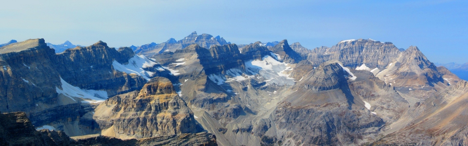
One of my favorite panoramas to date! Click to view larger.
.jpg)
Mount Temple's corniced east ridge is faintly visible peering up beyond Mounts Quadra and Bident.
.jpg)
The other side of the Fay Glacier. The more commonly seen side hangs high over Moraine Lake.
.jpg)
What a view! Click to see larger.
.jpg)
Panorama Ridge with the peaks of the Skoki area beyond.
.jpg)
Fossil Mountain visible in the distance (center left with a vertical band of snow near the top). Brachiopod Mountain and Mount Anthazoan to the right. All highlights of my summer trip into Skoki, although one moment in particular on top of Fossil Mountain stands out…
;)
.jpg)
Mounts Douglas and St. Bride to the northeast.
.jpg)
A suddenly diminuitive-looking Castle Mountain to the east.
.jpg)
Another summit added to the list!
.jpg)
Hero shot.
.jpg)
Storm Mountain (left), Mount Ball (distant center) and Stanley Peak make for a spectacular panorama looking back towards Banff. Click to see larger.
.jpg)
An excellent view of the scramble route up Storm Mountain. The route starts from the cirque in the center of the peak and follows the “s-shaped” scree cone through gullies to the flatter top of this continental divide peak.
.jpg)
Beautiful Mount Ball.
.jpg)
Aurore summit sandwich.
.jpg)
Rather than downclimb the steep loose exposed gully that we ascended, we opted to scree down pleasant south-facing slopes into a large cirque. The scree skiing was pretty good and we made excellent time! Moreover, after being beaten down by the sun (we were all running VERY low on water) all day, it felt amazing to get into the shade of the cirque!
.jpg)
To start our scree ski down into the cirque, we descended to the col between Whymper and the peak to the west. Ultimately, this wasn’t necessary as the south slopes can be scree’d down from more or less anywhere to get into the cirque. This small side trip did, however, provide us with a last impressive view of the Ten Peaks, Chimney Peak, Mount Quadra and Mount Bident. It also allowed me to fill my Nalgene bottle with snow from the quickly disappearing glacier on Whymper’s north face!
.jpg)
Continued amazing views of the Stanley Glacier from the cirque. Weary of other people’s trip reports which mention unpleasant thrashing through brush and deadfall below this cirque, we angled skier’s left along (mostly) open grass slopes above the larch trees pictured here.
.jpg)
We descended grass slopes to below the rock band in the photo here and then continued to work our way left, aiming for our original ascent gully which avoids the thrash through deadfall and new growth that lies directly below.
.jpg)
While our route was not completely free of deadfall, we managed to dodge most of it. Mike’s legs even survived despite wearing shorts! At one point, we found a game trail traversing left which accelerated our progress nicely.
.jpg)
Aurore stopping to enjoy some fresh raspberries. Nothing else that lives up here enjoys eating berries this time of year, right?
From here, we easily rejoined our original ascent avalanche chute which made for a pleasant, bushwhacking-free descent. While the side-hilling that we had to do to get back to this gully was time-consuming, I doubt it was more-so than thrashing straight down over all of the deadfall below the cirque.
.jpg)
All down! Not sure whether the beer or the ice cream disappeared more quickly!
.jpg)
.jpg)
.jpg)