Thanks to a late Friday night, we overslept and started our morning a little sluggishly. After clearing the cobwebs with some McDonald’s breakfast and dropping Crux off at the kennel for the day, we decided that there was still time to take on a scramble, provided that it was a short one. Based on Kane’s round-trip time of 3 – 5 hours for Mount Arethusa, we reasoned that it would provide a suitable objective. What we hadn’t banked on was that Alan Kane, apparently, moves significantly faster than we do over difficult terrain. We found the parking area easily and were surprised at the number of vehicles that were already there. Generally, difficult ratings have a way of scaring off the masses. We soon discovered, however, that everyone else was there to climb Little Arethusa and that we would have the bigger Arethusa to ourselves (a blessing given the rock fall hazard that we would later encounter in the descent gully).
.jpg)
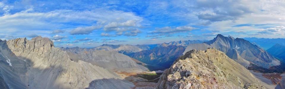
Mount Arethusa as seen from Pocaterra Ridge across Highwood Pass. The ascent route uses scree slopes on the right to gain the ridge crest where the “interesting” scrambling begins and continues for a reasonably lengthy traverse. A deep gully on the left provides a faster alternative to the ridge crest on descent.
.jpg)
Although Kane suggests that you stay on the left side of the drainage from the parking area, we found a well-worn path heading towards Little Arethusa on the right-hand side. After a few minutes, the path crosses a small stream (shown here) and continues more steeply up a dry drainage, leading quickly to alpine meadows between Little Arethusa (closer to the highway) and Mount Arethusa (further away from the highway).
.jpg)
Beautiful alpine meadows with the north cliffs of Little Arethusa on the left and Mount Arethusa on the right. The large notch in the center of the photo is Mount Arethusa’s alternate descent route. This descent route must be dry (several other trip reports can attest to the difficulties encountered in this notch when snow remains) if it is to be used. This spot provides an excellent vantage point to scout out the descent. From here, we crossed pleasant meadows to the right in order to gain the scree ascent slopes of Arethusa (just out of frame to the right).
.jpg)
We had company in the meadow. Bighorn sheep enjoy the view of Storm Mountain. On the far left of the photo, you can see the scree ascent slopes that provide access to Arethusa’s ridge crest.
.jpg)
Interrupting someone’s lunch.
.jpg)
The scree ascent slopes on the south side of Mount Arethusa. The rock ribs to the right provided a break from the tedium of the scree.
.jpg)
Brianne making her way up the loose terrain.
.jpg)
Once on the ridge crest, the terrain is initially easy. Here Brianne enjoys a nice break between the slog behind her and the exposed ridge crest ahead.
.jpg)
Easy going for now...
.jpg)
Looking back to the col between Mount Arethusa and scenic Storm Mountain. This col is where we first gained the ridge crest. Click to see larger.
.jpg)
A sharp outlier of Mount Rae on the other side of the ridge. Banded Peak can be seen in the distant center.
.jpg)
The ridge beginning to look a little more interesting.
.jpg)
Our first short detour off of the ridge crest. We detoured very slightly to the left side and used this gully to regain the ridge crest a moment later.
.jpg)
Another short detour, this time to the right of the ridge crest. The exposure becoming more significant as we proceed.
.jpg)
Arethusa casts a long shadow on two small lakes a long way STRAIGHT down to the east.
.jpg)
One of the lakes to the east.
.jpg)
Approaching Kane’s crux section of the ridge. The chimney which you must down climb is visible on the left a short distance ahead.
.jpg)
Yours truly carefully negotiating an exposed section to get to the chimney.
.jpg)
A 2 m down climb grants you access to the chimney, which requires a further 5 m of down climbing to the right side of the ridge. Near the top, the down climbing is easy, however, towards the bottom, the skier’s right side of the chimney disappears and you are confronted with a pulse accelerating drop to the valley below.
.jpg)
Down climbing the most exposed section of the chimney.
.jpg)
Past the chimney, we followed Kane’s advice and quickly crossed over to the left side of the ridge, using slab and ledges to avoid the ridge crest.
.jpg)
Eventually, the ledges funneled us back onto the ridge crest, just after a down climb that would have proven exceptionally difficult (just behind Brianne in this photo). Despite the fact that the crux is now behind us (visible as the dark crack in the center behind Brianne), this ridge was far from easy.
.jpg)
Brianne in the middle of an awkward move on an exposed bit.
.jpg)
Stuck.
.jpg)
Eventually, the exposure eases a little and the view of Mount Rae to the north lulls you into the impression that the remainder of the scramble will be a pleasant, scenic plod. Indeed, Kane even goes so far as to suggest that there are “no further difficulties past here.” Of course, he is lying. Click to view larger – try to spot Brianne.
.jpg)
Mount Rae’s eastern outlier.
.jpg)
Proof that the remainder of the scramble still presents some difficulties. This particular shot was taken from just before the summit, where we were forced to descend to an exposed ledge on the left to avoid an exposed and technical down climb along the ridge crest.
.jpg)
Almost there! Brianne makes one last move before arriving on the summit. The exposed traverse that she just completed visible behind her.
.jpg)
Relieved to be on top! Now, how the hell do we get down?
.jpg)
Summit panorama looking along Arethusa’s exposed ridge crest. Mount Rae on the left and Storm Mountain on the right and prairies beyond to the east. Click to see larger.
.jpg)
Looking west towards the continental divide. Little Arethusa in the immediate foreground, Highwood Ridge (left) and Pocaterra Ridge (right) a little further back. Further still, Mounts Tyrwhitt (center) and Pocaterra (right). Mount Joffre (the highest peak in Kananaskis) visible on the distant horizon.
.jpg)
Happy to be on top? I asked for a smile and this is what I got! Despite appearances, she later told me that this, her first difficult scramble, was her favorite to date.
.jpg)
The view of Mount Rae from the summit of Arethusa is nothing short of awesome.
.jpg)
Looking back along the ridge to the interesting rock folds of Storm Mountain. The alpine meadow which we started in speckled with golden larches below.
.jpg)
Storm Mountain (left) and Mist Mountain (right – distant) complete the Misty Range to the southeast.
.jpg)
Happy summit couple.
.jpg)
One last view to the east before heading down. Prairies visible in the distance.
.jpg)
Not overly keen on retracing our steps along the exposed ridge, we decided to investigate Kane’s alternate descent route (visible as the first notch in the foreground). While other trip reports indicate that many people have gotten themselves into trouble in this steep gully, we were fortunate that it was dry and that we were the only ones descending.
.jpg)
The way down to the notch from the summit is obvious, however, the final 10 or so meters that you must descend to get into the notch are steep, smooth slab. Here Brianne is trying her best not to slide down the mountain.
.jpg)
The slabs on the skier’s left of the descent gully were littered with fossils most of the way down.
.jpg)
This gives you a good idea of what descending this gully is like. Kane himself acknowledges that this gully is “STEEP.” He also says that it makes for a quick descent...potentially very quick if you’re not careful.
.jpg)
The holds on the slab are not particularly good going down the gully. In many places, you need to use friction to wedge yourself between the slabs on either side of you, lowering yourself down one bit at a time.
.jpg)
Sneaking a peek at Storm Mountain from about half-way down.
.jpg)
Chockstones provide occasional obstacles in the gully. Here Brianne slides under a tunnel created by two of them. Those rocks that fall down the gully and do not wedge themselves into a tight spot gain a disturbing amount of speed and crash violently down. I would highly recommend that this gully only be descended by small parties close together. If another group started down while you were anywhere in the gully, things would get ugly fast.
.jpg)
Near the very bottom of the gully, one final large chockstone blocks the way. In order to get around it, we had to carefully use friction (good holds are few and far between here) to lower ourselves along the slab (on the right of the chockstone in this photo). You can make out the tattered remains of a rappel that someone else used to descend this section. Unfortunately, the rope was frayed and no longer anchored to anything solid.
.jpg)
What a relief! Back on scree and out of the gully!
.jpg)
Climbing Arethusa shows some serious backbone.
.jpg)
Soft ground! A pleasant change of pace!
.jpg)
A great view of the descent gully (the largest notch in the center).
.jpg)
A dozen or so bighorn sheep wonder what these two idiots were just doing coming down that gully.
.jpg)
Beautiful late evening light on Storm Mountain. Perhaps we should consider leaving a little earlier in the morning next time?
.jpg)
Sunset on Mount Arethusa. Luckily, the hike out is short! We made it back to the car with about 10 – 15 minutes of daylight to spare.
.jpg)
Enjoying a well-earned pint at the Kananaskis Lodge.
.jpg)
.jpg)
.jpg)