Mount Fullerton
Elevation: 2728 m
Elevation Gain: 1050 m
Part of the Fischer Range, Mount Fullerton was named in 1940 after local rancher Jake Fullerton.
My Ascents:
June 28 2011
Trailhead: Little Elbow Day Use Parking Lot
Elevation: 2728 m
Elevation Gain: 1050 m
Part of the Fischer Range, Mount Fullerton was named in 1940 after local rancher Jake Fullerton.
My Ascents:
June 28 2011
Trailhead: Little Elbow Day Use Parking Lot
One the evening of June 27 2011, I lay in bed perusing Alan Kane’s “Scrambles in the Canadian Rockies” (as I often do) searching for inspiration. I had a deep yearning to try a new peak solo the next day after already completing a number of repeat season starter scrambles. For reasons that I don’t, to this day, understand, Mount Fullerton leapt out from the pages of the book and captivated me. Well, that was that, Mount Fullerton it is!
.jpg)
When I made the decision to climb Fullerton, I must have glossed over all the parts in the book describing this LONG uninspiring approach (ca. 10 km) up Nihahi Creek. As bad as the approach was on the way in, it was 20 times worse on the way out!
.jpg)
At least there were a couple wildflowers out to liven up the long trudge.
.jpg)
After 10 km of walking, the objective, Mount Fullerton, finally appears. My ascent route went up a drainage into the snowy basin (behind the treed hump) in the center before eventually gaining and ascending the north (climber’s right) ridge. On descent, I ended up shortcutting and coming straight down the north ridge just left of the cliffs visible in the bottom right of this photo.
.jpg)
The drainage that I ascended. The gushing creek proved to be good company on a solo ascent.
.jpg)
Finally at the top of the drainage and in the basin looking to the summit. At this point, my feet were already starting to get sore and, inexplicably my 2.5 L of water was already starting to run out.
.jpg)
On the north ridge with the summit within striking distance. According to Kane the skyline ridge on the left is an alternate route involving the use of ledges. Click to see larger.
.jpg)
Taking a breather and enjoying the view Mount Howard to the north.
.jpg)
Fortunately after the drudgery of the LONG approach, the scrambling on the summit ridge was pretty fun. No more hands in pocket walking!
.jpg)
Final section of the summit ridge. Not nearly as bad as it looks.
.jpg)
On top of my 11th summit of the year!
.jpg)
Fischer Peak, prominent to the west from the summit.
.jpg)
Looking west to the peaks of the Kananaskis Valley.
.jpg)
Lengthy Nihahi Ridge and the prairies to the east.
.jpg)
The southern section of Nihahi Ridge and flat-topped Forgetmenot Mountain beyond.
.jpg)
Calgary through the haze on the other side of Nihahi Ridge.
.jpg)
Posing in front of Mount Glasgow (immediately to the right of me) and Mount Cornwall (one peak to the right of Glasgow).
.jpg)
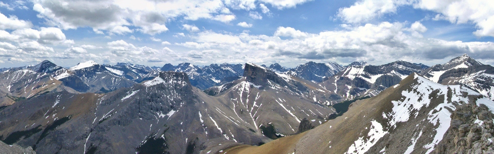
The panorama to the south was absolutely spectacular and completely justified all of the suffering involved in the long approach! From left to right: Mount Glasgow, Mount Cornwall, Mount Remus, Mount Romulus and Fischer Peak. Click to see larger.
.jpg)
The impressive summit blocks of Mounts Romulus and Remus
.jpg)
Checking out the supposedly easier route up Mount Remus' flat-top.
.jpg)
Mount Romulus.
.jpg)
Summit shot with Fischer Peak.
.jpg)
According to the register, I'm only the second one up here this year!
.jpg)
In the distance, Mount Assiniboine in the clouds beyond Mount Galatea and the Tower.
.jpg)
I certainly did not expect to see all the way to Banff up here! Cascade in the distance.
.jpg)
Mount Rundle as well.
.jpg)
The glaciated summit of Mount Joffre beyond the sharp cliffs of Mount Romulus.
.jpg)
The sun shines on Mount Bogart (left) and Mount Sparrowhawk (right) over the Kananaskis Valley.
.jpg)
Bogart.
.jpg)
Sparrowhawk.
.jpg)
Kananaskis Valley panorama. Click to see larger.
.jpg)
The alternative route down: the south-east ridge looked pretty tricky, especially with snow. Although I contemplated trying it, ultimately I decided to head back down the north ridge which I ascended. On the way down it, however, I stayed on the ridge and descended easily straight down into the valley, by-passing the basin and drainage to the east through which I ascended.
.jpg)
One last shot on the summit before heading down and starting the LONG plod back to the car. By the time I got there, I was completely out of water and my feet hurt like hell. Not sure that this peak will be repeated anytime soon thanks to the miserable approach, however, the view from the top really was worth it (once at least)!