Mount Cory
Elevation: 2802 m
Elevation Gain: 1400 m
William Wallace Cory served as Deputy Minister of the Interior between 1905 and 1930. In his honor, the peak(s) colloquially named “Hole-in-the-Wall Mountain” was rechristened Mount Cory in 1923. Mount Cory actually features two equally high summits a very short distance apart from one another. The mountain’s original name is a reference to the large cave on its flank which can readily be seen from the Bow Valley. This cave is thought to have formed as the result of melt-water from the region’s last significant glaciation. The cave has, apparently, been used as a location for secretive Freemason meetings in the past.
My Ascents:
September 28 2011, July 11 2010
Trailhead: Mount Cory Parking (Roadside)
Wednesdays are the best days for scrambles. Just think: if you climb a mountain on a Wednesday, you only have to wait 2 more days before you do it again! Truth be told, every day is a Wednesday (or Friday or Saturday or whatever you please) when you’re not working. Regardless, this Wednesday in particular seemed like a good time to get out and bag another peak! Flying solo (as has been a common theme this year), I decided to try a repeat. I climbed Mount Cory last summer and remember the ascent being scenic and trivial in terms of technical difficulty. Turns out that things are a little trickier when they’re covered in snow…
.jpg)
Mount Cory (much like Cory Pass) gets off to a “quick start”. There’s no approach here. After slogging up steep uninspiring slopes for 900 vertical meters, I was greeted with a stunning view of Banff, now far below.
.jpg)
The vertically tilted rock strata leading to the summit of Mount Cory, still a long ways off. After a steep start, the angle on Cory gears down and you’re left with a surprising amount of distance to cover before reaching the summit(s).
.jpg)
Fall colors nestled in between the vertical rocks.
.jpg)
Much like Moses, I found a burning bush on the mountain. This one, however, provided only one commandment: “Go forth and summit!”
.jpg)
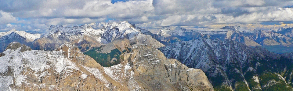
High up on Mount Cory, the three peaks of Mount Edith (foreground) finally become visible across Cory Pass.
.jpg)
The lowest, but most difficult, south summit of Mount Edith. Looks possible...
.jpg)
Is it just me or are these summits getting snowier? A disconcerting trend to be sure...
.jpg)
While I found the Mount Cory scramble to be relatively easy with dry conditions last summer, the winter conditions near the top made things much more interesting this time about. While the snow was manageable, the layer of verglass ice coating all the rocks just underneath it meant that this ascent had to be completed with care! In the summer, I stuck to the ridge crest, however, this time I tried to side-slope just below it on the east face – big mistake. This slope was all snow-mud and keeping myself adhered to the face of the mountain proved a significant challenge.
.jpg)
Banff at the foot of Mount Rundle.
.jpg)
Winter on top. Fall in the valley. Sigh.
.jpg)
Golden larches dot the base of Panorama Ridge. Temple behind, soaring in the clouds.
.jpg)
The three peaks of Mount Edith in the foreground as the sun shines on Mount Norquay behind them. In the background, a shady Cascade Mountain, Mounts Inglismaldie, Girouard, and Peeche across the Bow Valley.
.jpg)
Across the Bow: Mount Howard Douglas and Eagle Mountain (aka: Sunshine and Goat's Eye), Mount Bourgeau and Mount Brett.
.jpg)
Mount Bourgeau. You can just make out Bourgeau Lake tucked into the bottom right amidst some golden larches.
.jpg)
Bourgeau looks fairly intimidating (from this angle at least)!
.jpg)
Storm Mountain.
.jpg)
It's been a while since I've gotten to see the top of Assiniboine...
.jpg)
Documenting #48.
.jpg)
The summit of Mount Ball, looking relatively inhospitable at the moment.
.jpg)
I still want to do Mount Aylmer, but at this point the 12 km hike in and 1680 vertical meters required seem better-suited to the long daylight hours of summer.
.jpg)
Prominent K-Country peaks. Mounts Sparrowhawk and Bogart on the left. The pointy Old Goat Mountain on the right.
.jpg)
Sparrowhawk and Bogart.
.jpg)
Old Goat.
.jpg)
Mount Howard Douglas and Eagle Mountain. Sadly ski season and its inherent crowds appear to be upon us.
.jpg)
I love this sharp peak in the distance beyond Sunshine but haven't had any luck putting a name to its proverbial face.
.jpg)
The ass end of the Valley of the Ten Peaks.
.jpg)
Temple and Castle bookending the Bow Valley.
.jpg)
Back in the land of the living. Actually by sticking to the icy ridge on descent, I made my life a lot easier (and less terrifying) than it was on ascent.
.jpg)
Last views of Brett and Pilot Mountain from a high plateau before heading back down valley-wards.