I do not like the taste of scrambling failure. And, unfortunately, that was the taste that Castle Mountain left in my mouth late last fall. On that day, despite clear skies at Rockbound Lake, Mike and I were stuck in a complete whiteout on the broad plateau higher up. With no way of knowing where the exact “summit” was and short daylight hours working against us, we ended up retreating without reaching our goal. This time, with Grant, I planned to take advantage of the much warmer August weather and longer days to return to the peak and change my Castle Mountain fortunes.
.jpg)
After ~6 km of uninspiring walking (at Grant speed) towards Rockbound Lake, the Eisenhower Tower, the southeastern-most point of Castle Mountain is revealed through the forest.
.jpg)
The last time Mike and I attempted to climb Castle, we found no wildflowers, only snow.
.jpg)
Despite the length of the approach (8.4 km), the aptly-named Rockbound Lake is beautiful. It would be a pity to stop here (at the end of the official hike), however, as things only get prettier from here on up!
.jpg)
Quickly gaining elevation on the flanks of Helena Ridge on the north side of Rockbound Lake.
.jpg)
A small grassy terrace high above Rockbound Lake.
.jpg)
The approach on Castle Mountain is mildly ridiculous. You walk up the green valley in the picture for 8.4 km to Rockbound Lake, then climb up behind the lake's left (in this photo) shore before circling around the entire lake on a large rocky plateau. Having accomplished all of this, you must now walk back towards where you started to gain the summit shown in the distance here. Even if you only go to bag Castle Mountain itself and not the other 3 peaks present on the Castle massif, expect a long day and sore feet!
.jpg)
After much plodding, we encountered a gap in the ridge offering a pleasant view down to the Bow Valley.
.jpg)
Approaching the summit...Helena Ridge behind Rockbound Lake. You can see the avalanche chutes behind Rockbound Lake that we ascended and the grassy limestone terrace that we crossed a few photos ago.
.jpg)
Grant enjoying the view.
.jpg)
Finally on top of Castle Mountain with much clearer skies than last time! 28th summit bagged this year!
.jpg)
Looking across the Bow Valley to the Valley of the Ten Peaks.
.jpg)
Although Castle is the easternmost peak in the main ranges, the Waputik Icefield is still clearly visible from the summit. Here from left to right, you can see: Mount Niles, Mount Des Poilus (distant), Mount Daly and Mount Balfour.
.jpg)
Main range panorama to the west. Click to see larger.
.jpg)
The adjacent, but well-separated Eisenhower Tower.
.jpg)
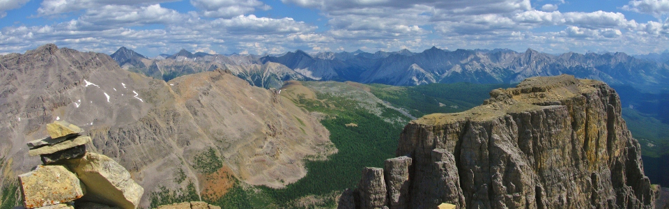
Front range panorama to the east. Click to see larger.
.jpg)
Mount Ishbel and the appropriately named Sawback Range beyond the Eisenhower Tower.
.jpg)
Mount Rundle in the distance over Banff.
.jpg)
A picture-perfect view of Mount Assiniboine.
.jpg)
King of the Castle.
.jpg)
Looking into Kootenay National Park directly across the Bow Valley: Mount Ball, Storm Mountain and Stanley Peak.
.jpg)
Mount Ball.
.jpg)
Taylor Lake and Panorama Ridge in front of the Valley of the Ten Peaks and Temple.
.jpg)
The register was full so I signed some time back in 2007.
.jpg)
The bridge over the Bow at Castle Junction 1.4 km below.
.jpg)
The impressive gap between Castle Mountain and the Eisenhower Tower.
.jpg)
Grant sending his regards.
.jpg)
Shapely Pilot Mountain across the Bow Valley back towards Banff.
.jpg)
After making good time to the summit of Castle, we reasoned that it would be a shame to undertake such a long approach without going for one (or more) of the other peaks present on the Castle Mountain massif. Here, Grant starts the long trudge towards our next objective: Stuart Knob.
.jpg)
Stuart Knob and a more distant TV Peak. Three'fer?!
.jpg)
Stuart Knob is deceptively far from Castle Mountain! The long plod along the rocky plateau in the hot August sun took quite a toll on our water supply! Luckily for Grant (who ran out), we found this alpine stream high on the plateau near Stuart Knob.
.jpg)
Finally at the base of the Knob. From here, you must contend with a vicious treadmill of loose scree to get to more interesting scrambling just below the Knob's summit.
.jpg)
As promised, more interesting scrambling near the top of the Knob. The route circles around climber's left.
.jpg)
Grant negotiates the final few meters to the summit of Stuart Knob.
.jpg)
From the summit of the Knob, the scale of the Castle Massif is impressive! Click to see larger.
.jpg)
Looking back towards the (now) distant summit of Castle Mountain. Pilot Mountain, Copper Mountain and Mount Assiniboine provide a scenic backdrop!
.jpg)
TV Peak to the northwest. Kane claims that it's only 1.5 hours beyond Stuart Knob, but it looked significantly farther to us. It also looked as though you would have to lose and then regain a fair amount of elevation. Despite earlier plans, we therefore abandoned our hopes of a three for one summit day.
.jpg)
The TV repeater stations for which the peak is named. Some cool cornices too.
.jpg)
A pretty green tarn provides contrast to the red rock of the Castle massif.
.jpg)
Another register...
.jpg)
For my money, Stuart Knob offered a better view than Castle Mountain itself. Shown here, the Lake Louise group and Valley of the Ten Peaks.
.jpg)
Even Mount Victoria makes an appearance from the Knob (protruding behind Mount Temple).
.jpg)
An improved view of the Deltaform: dwarfing Eiffel Peak.
.jpg)
Summit #29. A LONG way down from here...
.jpg)
Mount Ball, Storm Mountain and Stanley Peak make their second appearance of the day.
.jpg)
Prior to this ascent, I had no idea that there was a gorgeous lake on the other side of Helena Ridge; this was my first view of remote Luellen Lake.
.jpg)
The remote Slate Range to the north.
.jpg)
Group summit shot before GTFD time!
.jpg)
Grant GTFD through a series of small rock bands below Stuart Knob.
.jpg)
Rather than retrace our steps towards Castle Mountain (right), we made a straight line back towards Helena Ridge (left) along this mossy stream. From there, where we would descend back to Rockbound Lake.
.jpg)
Castle Mountain panorama. Good God that's a long mountain. Summit on the left, Stuart Knob on the right. Between this and the 16.8 km round trip approach, I understand why my feet hurt the following morning. Click to see larger.
.jpg)
The marmots stick to Helena Ridge apparently. After not seeing any life for hours, we saw numerous marmots in a meadow at the base of the ridge.
.jpg)
Evening sun shimmering on Rockbound Lake. It must be getting late…
.jpg)
Back down to Tower Lake. Time for a 7.4 km jog to the car. Good thing I finished all of my water back at the foot of Stuart Knob.
.jpg)
Sweaty and about to DESTROY a Powerade after running down the entire Rockbound Lake trail without any water.
.jpg)
Nice rack.
.jpg)
The classic view of Castle Mountain from the highway.
.jpg)
.jpg)
.jpg)
.jpg)